
18th - 21st November 2011
A Marathon a Day for Three Days along The Pembrokeshire Coast Path.
Event Organisers:
DAY - THREE
 |
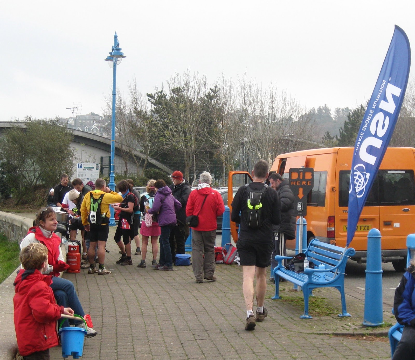
Portgain Harbour Last Minute Preparations
|
The start for Day 3 was just a short bus ride back to Porthgain and while everybody prepares for the off I try to do my usual photo shoot. However the camera after two days of running marathons is less than enthusiastic for doing a third but with a bit of gentle persuasion it's taking photos but with a problem, it won't let me view the image before I press the shutter but it will let me see the image afterwards, phew at least its working it would have been a disaster at this stage if it had packed up. By the time I have finished messing with the camera I look up to see all the other runners climbing the headland out of Porthgain and after getting a bit of grief out of the votwo crew I dib-in and set-off.
The forecast for today is to be bright and sunny after early morning mist & fog and with the wind abated it looks like it's going to be perfect conditions.
 |
| Climbing the headland from Portgain. |
On the climb out of Porthgain we pass a white pillar this is one of a pair set either side of the harbour mouth to act as navigational markers for small boats.
 |
| Runners on the cliffs in the early morning light. |
It's only just gone 8:00am and as I watch the others running along the cliff blue sky starts to break through the mist, it is looking promising for the last leg of the PCC Day 3.
 |
| Pen Castell-Coch |
In the photograph above Pwll Olfa is seperated from Pwll Llong by a small headland, the farthest headland is Pen Castell-Coch.
Now that we are well and truly back in Welsh Wales the place names are not surprisingly Welsh, already there are Pen's & Pwll's so here is a quick guide to Welsh names found along the coast.
aber – estuary/mouth of river
carreg – stone
castell – castle
coch – red
pen – head
pentir – headland
porth – port
mynydd – mountain
treath – beach
pwll – pool/pond/puddle/hollow is the literal translation however, pwll seems to be used extensively along the coast were you see a bay, cove, creek, inlet, basin?? (if anybody knows the definition for 'pwll' please let me know)
 |
| Runners Dwarfed by the Landscape |
The mist seems to have drifted in again as I notice an arch in the cliffs with the Island of Deullyn behind.
 |
| Sea Arch with Ynys Deullyn behind. |
It's only about 4.1/2 miles to the first checkpoint at Abercastle and it's not far beyond Ynys Deullyn so I hope to reach CP1 in less than an hour.
 |
| Ynys Duellyn |
A few minutes later Abercastle, the location for CP1, comes into view through the mist.
 |
| Abercastle |
Abercastle was a very busy trading port in the 19th Century. Cargoes included grain, limestone, butter, honey, corn, and coal. All that now remains of Abercastle's industrial past are limekiln remnants and a ruined grain store.
 |
| Abercastle |
 |
Checkpoint 1
|
I drop down to CP1 and dib-in I've been going 54 minutes, I am pleased with the time considering the delay on route caused by having to coax the camera into taking photos. I don't want to waste time and it's too early to stop so I just dib and carry-on. CP2 at Strumble Head Lighthouse is about 9 miles away along a very dramatic coastline, (dramatic in votwo speak usually means 'serious height gain and loss') and the first danger sign of the day gives some insight of the coast path that lies ahead.
 |
| Mae Clogwyni'n Lladdd Cadwch At Y Llwyber |
 |
| The dramatic coastline |
We are soon up on the cliffs and its very muddy, I slip and slide but I am determined to adhere to the signs instructions 'Keep To The Path'. After dropping down off the sea cliffs that flank Mynydd Morfa I arrive at Aber Mawr and run across this quiet secluded pebble beach with its marsh and woodland behind.
However for such a remote and relatively inaccessible beach, Aber Mawr has a surprising history of almost industrial development.
In 1849 following on from an elaborate survey to establish the best route to Ireland, Aber Mawr was selected over the current route via Fishguard. However in 1856 the Great Western Railway took over the project and luckily for the peace and quiet of Aber Mawr, Neyland was selected instead. Neyland, then a small fishing village became the site for the Western Terminus of Isambard Kingdom Brunel's Great Western Railway complete with a transatlantic terminal for the largest ships of the time.
 |
| Aber Mawr |
The next attempt at industrialisation was The Aber Mawr Cable Telegraph Station. In 1862 the Cable Ship Berwick laid the first cable for the Electric & International Telegraph Company, it was over 60 miles long and ran from Abermawr to Wexford, the shortest route across St George’s Channel to Ireland. The inland telegraph service was nationalised in 1870 and the General Post Office laid a second cable in1880 to Blackwater in Ireland.
The office was a corrugated tin hut in which the telegraph instruments were placed on rows of wooden benches and at the rear of the hut bunks provided sleeping quarters for the telegraph clerks. Telegrams received from Ireland were then re-transmitted to head office in London.
During the First World War the station provided an important link with North America and it was guarded by a small number of soldiers. Then in the1920’s a storm washed away the road above the beach and with it the ends of the two cables, shortly after this the station was abandoned and that was the end of Aber Mawr's brush with industrial development. The derelict corrugated hut was eventually purchased in 1951 and subsequently renovated turning it into a residential property, now it is let out as holiday accommodation .
After running across the beach at Aber Mawr you are obviously at sea level and so therefore the only way is up and up as the next section of coast is high and 'dramatic'.The office was a corrugated tin hut in which the telegraph instruments were placed on rows of wooden benches and at the rear of the hut bunks provided sleeping quarters for the telegraph clerks. Telegrams received from Ireland were then re-transmitted to head office in London.
During the First World War the station provided an important link with North America and it was guarded by a small number of soldiers. Then in the1920’s a storm washed away the road above the beach and with it the ends of the two cables, shortly after this the station was abandoned and that was the end of Aber Mawr's brush with industrial development. The derelict corrugated hut was eventually purchased in 1951 and subsequently renovated turning it into a residential property, now it is let out as holiday accommodation .
 |
| Pwllcochran Bay |
 |
| Breakfast Mushroom |
Throughout the three days that we have been running we have passed lots of mushrooms so I took time to take a photo of this one, unfortunately it's difficult to gauge its size on a photo but I had seen some very big ones, I think there is some wild mint just in front of it. Now if I could just locate some eggs and bacon, its never to late for brunch.
We climb up & up and into the mist where it is cooler and despite the fact that the mist is spoiling the view the next photograph does give a good impression of how high up we actually are:
Back we drop, down of the cliff tops and along a muddy path to join a metalled track before then turning on to Strumble Head.
We are still high up on the coast path and as I look back the sun is just trying to break through the mist and I can see the high cliffs that we have just run along from Penbwchdy.
As we round the headland Strumble Head Lighthouse comes into view which is the location of CP2. Although we are still in the mist the sun is actually shinning on the lighthouse and it's light is flashing.
The coast path is undulating and just like on day one muddy and slippy, as we get closer to Strumble Head Lighthouse you can just see the light flashing.
Strumble Head Lighthouse was built in 1908 by Trinity House ‘for the greater safety of sea traffic’ between Ireland and the new port of Fishguard. The new light also formed a link with the existing South Bishop light, 18 miles to the south-west. This stretch of coast is very dangerous and in the 19th Century alone some 60 vessels are known to have been lost.
The original revolving lens system weighed 4½ tons, so it was floated on a bath of mercury to reduce friction. It was rotated by a massive clockwork mechanism driven by a quarter-ton weight suspended by a cable which gradually dropped down a cylinder running from the top to the bottom of the tower, it had to be re-wound every 12 hours. Illumination was updated from paraffin to electricity in 1949 and the optical system was replaced by more compact equipment when the lighthouse was fully electrified in 1965.
Always a sight for sore eyes and tired legs, the 'Dibbing-In' Station at Checkpoint Two.
A sight for sore eyes? a stern look from Peter? I thought I was going to be told-off for taking photos! but actually Peter's concern was for some of today's walkers, they had 'settled-in' at CP2 and seemed to be enjoying themselves! joking with the staff and other runners. "Too much talking and not enough walking" Peter remarked. The reason Peter mans CP2 everyday is for safety (not just because its always set in a beautiful location), it is an important point for deciding if competitors that are struggling to meet cut-off times should be allowed to continue. That's why Peter is keen to keep everybody moving, it's a responsible job especially with the shorter daylight hours of mid-November and the dangerous cliff edges.
Soon after leaving CP2 I notice the Irish Ferry on route to Fishguard which is also the location of CP3, I ponder on whether I might beat it there but it very quickly becomes apparent I won't. All of a sudden with the mist gone and with blue skies and blue seas it looks more like a vista from somewhere warmer than Pembrokeshire in November.
I am pleased with my performance today I feel a lot better than yesterday and I am running well but I am soon to discover the secret of what votwo are feeding us at the checkpoints.
Back on the cliffs I manage to get a photo of some seals on the beach below. I conclude they must be Grey Seals, as they have their young in autumn and the one in the water is suckling a pup. Other seals found in the waters around Britain are Common or Harbour Seals and these give birth in late spring/early summer. Grey Seals are larger and have a very distinctive face, the scientific name, Halichoerus Grypus, actually means ‘sea-pig with a hooked nose’. Grey Seal pups weigh about 14kg at birth and have soft white fur. They remain on land for 18-21 days where they suck from their mother. The mothers milk contains up to 60% fat so the pups grow very quickly gaining about 2kg in weight each day. This weight mainly consists of a layer of blubber just below their skin which is vital insulation when they go to sea.
Along the coast from here and just before Fishguard was where the last unsuccessful invasion of Britain occurred in 1797. The French invasion force consisted of 1,400 troops from the La Legion Noire, The Black Legion, so called because they wore British uniforms captured from an earlier encounter and being bright red they dyed them black. They were a mixture of republicans, deserters, royalist prisoners and grenadiers and were very well armed and transported on four French warships.
The four warships under Commodore Jean-Joseph Castagnier were very impressive. Le Vengeance was one of the newest & largest French frigates, with 56 guns she was built for speed and manoeuvrability. La Resistance was also a fast & powerful frigate and on her maiden voyage. La Constance a new corvette was smaller than the frigates, lightly armed and very manoeuvrable and the Vautour was a new lugger with 16 guns, a formidable fleet.
Despite all this it was an ill-conceived plan. The forces landed at Carregwastad Head near Fishguard on 22 February after a failed attempt to enter Fishguard harbour itself. Upon landing discipline soon broke down amongst the irregulars, many of whom deserted to loot nearby settlements. The remaining troops were met by a quickly assembled group of only 500 British reservists, militia and sailors and they were bluffed into surrendering by Lord Cawdor Commander in Chief who claimed to have vastly superior numbers. In the meantime local heroine, Jemima Nicholas reputedly single handidly rounded up 12 Frenchmen with a pitch fork and confined them in the guard house in Fishguard.
The harbour at Fishguard was constructed by blasting 1.6 million tonnes of rock from the hillside to make a 900 metre long breakwater, the quarried-out area became the quay. The harbour was opened on 30th August 1906. However the breakwater lead to unanticipated silting in the harbour and the prospect of future visits from large liners was abandoned. However the British Cunard Liner RMS Mauretania visited once in 1909. Unable to dock, passengers had to be transported ashore by tender. At the time she was the largest and fastest ship in the world capturing the ‘Blue Riband’ for the fastest transatlantic crossing during her 1907 inaugural season, which she held for 22 years.
Its' a very steep road descent down off the cliffs and the pounding of the tarmac on tired legs is painful, but just past the entrance to Fishguard Harbour at Goodwick is CP 3.
I'm on a high, victory is well and truly in sight, from CP3 to the finish is approx 6.1/2 miles and while 6.1/2 miles of coast path running is not to be underestimated I feel confident that I can cover the distance in 1.1/2 hours. If I can I should finish the day in 6.1/2 hours and not the 7 I had anticipated.
I grab two chunks of Mrs Masons 'excellant' homemade chocolate brownie, down a big cup of coke and grab as many jelly beans as I can carry in one hand. All this sugar is contributing to an even bigger high that nearly made me forget to dib-in.
It's a tarmac path from Goodwick to the lower town of Fishguard and I set off at a blistering pace jelly beans flying off in all directions much to the amusement of the children, but I'm on one now and nothing is going to stop me finishing this 3 day challenge!
In this event 'just running' from one side of town to the other involves running over a big headland but it does provide me with a good viewpoint of Fishguard Lower Town, however it's a bit misty again and I decide, even though it is going to be picturesque down in the harbour, I will not stop (haven't time - on a mission now) to take photos but will come back at a later date on a better day with my camera and take some then and this was the result.
There is a long road climb out of Fishguard back up to the coast path, and I storm up it running strong and passing a couple of others on the way one commenting "whats he on? running like that after 70 bloody miles" I smirk, he must have missed out on the CRYSTALYX at the last checkpoint and then it's out onto the coast path. The mist thins enough to let the sun shine through so I take a photo of the final stetch of coastline, in the far distance at the left hand side of the photo is Dinas Head and on a small beach just before it is the finish. Fortunately there is no road access on to Dinas Head otherwise I suspect that it would have been yet another climb to the finish .
I'm still running hard and starting to doubt if I can keep this pace all the way to the finish but 'this is what I do' 'this my territory' this is were I always feel strong, I get this feeling towards the end of an Ironman a combination of elation and determination feeding a new found strength. I pass other runners some in small groups and some running on their own but everyone knows that we are nearly there, the finish at Pwllgwaelod never seems to get closer then all of a sudden from the top of the headland I can see it!
The finish at Pwllgwaelod is a pretty little cove which was frequently used by smugglers and has an old fisherman's pub virtually on the beach. Their aren't thousands of spectators lining the road waiting to cheer me in just a few puzzled holiday makers, but hey who cares! this is my sort of event.
I finished in a time of 6 hours 34 mins for the 28 mile-ish marathon and I am well pleased with this considering how arduous the last day has been. Two cup fulls of Mrs Mason's homemade soup, half a loaf of bread then a short bus ride back to St. Davids. Well thats it The Pembrokeshire Coast Challenge 78.6 miles, 3 days, 2 feet with about 17.1/2 hours of running, done, dusted and in the bag. (until the next one?)
The End.
 |
| Ynys Melyn and Pen Brush |
 |
| Muddy Path |
Back we drop, down of the cliff tops and along a muddy path to join a metalled track before then turning on to Strumble Head.
We are still high up on the coast path and as I look back the sun is just trying to break through the mist and I can see the high cliffs that we have just run along from Penbwchdy.
 |
| The headland of Penbwchdy |
As we round the headland Strumble Head Lighthouse comes into view which is the location of CP2. Although we are still in the mist the sun is actually shinning on the lighthouse and it's light is flashing.
 |
| The undulating coast path leading to Strumble Head Lighthouse |
 |
| Just another muddy path |
The coast path is undulating and just like on day one muddy and slippy, as we get closer to Strumble Head Lighthouse you can just see the light flashing.
 |
| Strumble Head Lighthouse |
Strumble Head Lighthouse was built in 1908 by Trinity House ‘for the greater safety of sea traffic’ between Ireland and the new port of Fishguard. The new light also formed a link with the existing South Bishop light, 18 miles to the south-west. This stretch of coast is very dangerous and in the 19th Century alone some 60 vessels are known to have been lost.
 |
| Strumble Head Lighthouse |
The original revolving lens system weighed 4½ tons, so it was floated on a bath of mercury to reduce friction. It was rotated by a massive clockwork mechanism driven by a quarter-ton weight suspended by a cable which gradually dropped down a cylinder running from the top to the bottom of the tower, it had to be re-wound every 12 hours. Illumination was updated from paraffin to electricity in 1949 and the optical system was replaced by more compact equipment when the lighthouse was fully electrified in 1965.
 |
| Checkpoint 2, Dib Dib! |
Always a sight for sore eyes and tired legs, the 'Dibbing-In' Station at Checkpoint Two.
 |
| Checkpoint Two at Strumble Head |
A sight for sore eyes? a stern look from Peter? I thought I was going to be told-off for taking photos! but actually Peter's concern was for some of today's walkers, they had 'settled-in' at CP2 and seemed to be enjoying themselves! joking with the staff and other runners. "Too much talking and not enough walking" Peter remarked. The reason Peter mans CP2 everyday is for safety (not just because its always set in a beautiful location), it is an important point for deciding if competitors that are struggling to meet cut-off times should be allowed to continue. That's why Peter is keen to keep everybody moving, it's a responsible job especially with the shorter daylight hours of mid-November and the dangerous cliff edges.
 |
| The Irish Ferry |
Soon after leaving CP2 I notice the Irish Ferry on route to Fishguard which is also the location of CP3, I ponder on whether I might beat it there but it very quickly becomes apparent I won't. All of a sudden with the mist gone and with blue skies and blue seas it looks more like a vista from somewhere warmer than Pembrokeshire in November.
I am pleased with my performance today I feel a lot better than yesterday and I am running well but I am soon to discover the secret of what votwo are feeding us at the checkpoints.
 |
| So potent its kept behind a barbed-wire fence. |
Back on the cliffs I manage to get a photo of some seals on the beach below. I conclude they must be Grey Seals, as they have their young in autumn and the one in the water is suckling a pup. Other seals found in the waters around Britain are Common or Harbour Seals and these give birth in late spring/early summer. Grey Seals are larger and have a very distinctive face, the scientific name, Halichoerus Grypus, actually means ‘sea-pig with a hooked nose’. Grey Seal pups weigh about 14kg at birth and have soft white fur. They remain on land for 18-21 days where they suck from their mother. The mothers milk contains up to 60% fat so the pups grow very quickly gaining about 2kg in weight each day. This weight mainly consists of a layer of blubber just below their skin which is vital insulation when they go to sea.
 |
| Grey Seals |
Along the coast from here and just before Fishguard was where the last unsuccessful invasion of Britain occurred in 1797. The French invasion force consisted of 1,400 troops from the La Legion Noire, The Black Legion, so called because they wore British uniforms captured from an earlier encounter and being bright red they dyed them black. They were a mixture of republicans, deserters, royalist prisoners and grenadiers and were very well armed and transported on four French warships.
The four warships under Commodore Jean-Joseph Castagnier were very impressive. Le Vengeance was one of the newest & largest French frigates, with 56 guns she was built for speed and manoeuvrability. La Resistance was also a fast & powerful frigate and on her maiden voyage. La Constance a new corvette was smaller than the frigates, lightly armed and very manoeuvrable and the Vautour was a new lugger with 16 guns, a formidable fleet.
Despite all this it was an ill-conceived plan. The forces landed at Carregwastad Head near Fishguard on 22 February after a failed attempt to enter Fishguard harbour itself. Upon landing discipline soon broke down amongst the irregulars, many of whom deserted to loot nearby settlements. The remaining troops were met by a quickly assembled group of only 500 British reservists, militia and sailors and they were bluffed into surrendering by Lord Cawdor Commander in Chief who claimed to have vastly superior numbers. In the meantime local heroine, Jemima Nicholas reputedly single handidly rounded up 12 Frenchmen with a pitch fork and confined them in the guard house in Fishguard.
 |
| The Breakwater at Fishguard |
The harbour at Fishguard was constructed by blasting 1.6 million tonnes of rock from the hillside to make a 900 metre long breakwater, the quarried-out area became the quay. The harbour was opened on 30th August 1906. However the breakwater lead to unanticipated silting in the harbour and the prospect of future visits from large liners was abandoned. However the British Cunard Liner RMS Mauretania visited once in 1909. Unable to dock, passengers had to be transported ashore by tender. At the time she was the largest and fastest ship in the world capturing the ‘Blue Riband’ for the fastest transatlantic crossing during her 1907 inaugural season, which she held for 22 years.
 |
| Checkpoint 3 at Goodwick/Fishguard |
Its' a very steep road descent down off the cliffs and the pounding of the tarmac on tired legs is painful, but just past the entrance to Fishguard Harbour at Goodwick is CP 3.
I'm on a high, victory is well and truly in sight, from CP3 to the finish is approx 6.1/2 miles and while 6.1/2 miles of coast path running is not to be underestimated I feel confident that I can cover the distance in 1.1/2 hours. If I can I should finish the day in 6.1/2 hours and not the 7 I had anticipated.
I grab two chunks of Mrs Masons 'excellant' homemade chocolate brownie, down a big cup of coke and grab as many jelly beans as I can carry in one hand. All this sugar is contributing to an even bigger high that nearly made me forget to dib-in.
It's a tarmac path from Goodwick to the lower town of Fishguard and I set off at a blistering pace jelly beans flying off in all directions much to the amusement of the children, but I'm on one now and nothing is going to stop me finishing this 3 day challenge!
 |
| Fishguard Lower Town |
In this event 'just running' from one side of town to the other involves running over a big headland but it does provide me with a good viewpoint of Fishguard Lower Town, however it's a bit misty again and I decide, even though it is going to be picturesque down in the harbour, I will not stop (haven't time - on a mission now) to take photos but will come back at a later date on a better day with my camera and take some then and this was the result.
 |
| The Quay at Fishguard |
 |
| The Final Stretch of Coastline |
I'm still running hard and starting to doubt if I can keep this pace all the way to the finish but 'this is what I do' 'this my territory' this is were I always feel strong, I get this feeling towards the end of an Ironman a combination of elation and determination feeding a new found strength. I pass other runners some in small groups and some running on their own but everyone knows that we are nearly there, the finish at Pwllgwaelod never seems to get closer then all of a sudden from the top of the headland I can see it!
 |
| The Finish at Pwllgwaelod |
The finish at Pwllgwaelod is a pretty little cove which was frequently used by smugglers and has an old fisherman's pub virtually on the beach. Their aren't thousands of spectators lining the road waiting to cheer me in just a few puzzled holiday makers, but hey who cares! this is my sort of event.
 |
| Three Runners Striding In To Victory. |
 |
| The Finish - Dibbing In on the Beach. |
I finished in a time of 6 hours 34 mins for the 28 mile-ish marathon and I am well pleased with this considering how arduous the last day has been. Two cup fulls of Mrs Mason's homemade soup, half a loaf of bread then a short bus ride back to St. Davids. Well thats it The Pembrokeshire Coast Challenge 78.6 miles, 3 days, 2 feet with about 17.1/2 hours of running, done, dusted and in the bag. (until the next one?)
The End.
No comments:
Post a Comment